C-MAP Plan2Nav app for iPhone and iPad
4.8 (
4208 ratings )
Travel
Navigation
Developer:
C-MAP Italy s.r.l
Free
Current version:
1.6.8, last update: 6 years ago
First release : 30 Mar 2011
App size: 51.97 Mb
C-MAP has developed the ultimate navigation and planning tool for today’s “mobile” society. From passionate, experienced boaters to casual travelers, Plan2Nav helps you receive more enjoyment from your time on the water, everywhere around the world.
Are you ready to map?
Our exclusive free app includes outstanding worldwide background charts, so you can start planning your journey right away! Plan your next cruise, set routes, look for marinas along your voyage or even share the tracks of your last adventure…these are just some of the things you can do with Plan2Nav.
Advanced navigation features
Like a “handheld chartplotter,” Plan 2Nav lets you:
-View charts in “birds eye” Perspective View
-Enable GPS to track Speed Over Ground (SOG), Course Over Ground (COG) and Estimated Time of Arrival (ETA).*
-Create and edit routes
-View GPS tracks
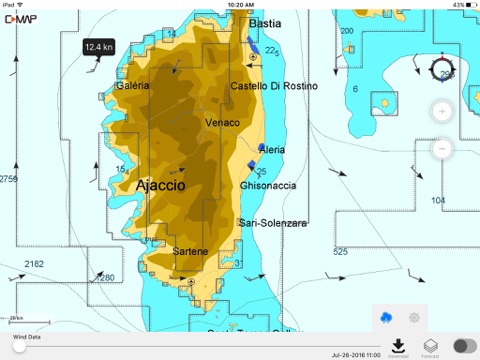
-Download free weather for a five-day forecast overlaid onto the chart
-Select North Up or Course Up orientation for a fully rotating vector visualization
-View Clock, Compass and set Distance Units
Complete the Journey - Upgrade to full C-MAP cartography
Purchase affordable, expansive map coverage to unlock the full potential of Plan2Nav. Benefit from the features and award-winning technology that have made C-MAP the choice of more than 1 million boaters worldwide:
-NavAids
-Detailed Harbor Charts
-Exclusive Aerial Photos and Diagrams
-C-Marina Ports Database
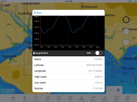
-Dynamic Tides and Current Predictions
-Depth Contours and Land Elevations
Once downloaded, these feature-packed maps stay recorded on the device and are always accessible – even when no wireless connection is available
* Continued use of GPS running in background can reduce battery life
Video Tutorial:
http://www.youtube.com/watch?v=JU32ObxRW-M&feature=youtu.be
Pros and cons of C-MAP Plan2Nav app for iPhone and iPad
C-MAP Plan2Nav app good for
price of maps are fair, poi quite ok, maps good for normal navigation needs. (i use german inland map) a gpx upload function to the device is missing. quite handy for normal use. definitly to recomment...
Works great on my iPad. Map detail for lake Ontario is better then navionics. The main annoyance is the tilt view activating when you try to zoom in or out. Anchor watch is a good feature to have. I especially like how all the info is displayed. Accessing the marina images is also too cumbersome but glad its there anyway. Cant wait for new version. Im running os5 and have not had crashes like others describe. I also think its an app geared towards an iPad.
I got canada lakes for 20bucks! Didnt expect much but from what ive seen so far its pretty precise and the data( depth, vegetation, etc...) is pretty accurate. I use this on my iphone. Easy to use, marking spots, tracking, waypoints... Im not a GPS specialist and i found my way around
This app is way better the the navionics A lot more detail and functions. If you goto the jeppeson web site you can download the user manual into iBooks. It is a big help to fully understand how the app works.
I replaced my IPad and could not access the charts. But if you deleate the app then reinstall you can then re download the charts. Now everything works great.
CaptBill on Southern Comfort
Number of depth indications are more the other charts. You can see some weather data nereby your location ie. wind force and directions.
Some bad moments
The software is fine. But you should know that the standard iPad without 3G doesnt support GPS tracking. I bought the software and cannot use it.
So be careful !!!!
GPS isnt working in many circumstances even if other apps have signal. A yellow bar with no content appears on the top and does not go away. The German map has many mistakes in content and spelling. The idea and functionality of the app is great but realization very poor.
Cant figure out how to downlaod/purchase detail content Using iPhone 4. it just keeps kicking me out with a message - "Contact Customer Support" The support link given above drives me to a site with no information on the App.
The $20 for downloaded Charts looked good but disappoints. The detail in the charts is definitely there but seemingly not the means to use it. Whats missing is some general help and instructions on using the features of the app. Cant find how to do things such as plotting a course and setting waypoints. This basic should be a given. Is just digital charts for now.
Terrible Customer Support.
App does not work, Support says working on a fix... 2 months now...
Why make an update, when you obviously didnt test it?
I finally found a Navigation App for my area of boating.
Too bad it is broken and no longer works. Bad support. I cant download my maps I purchased from the App!
If I could rate it zero I would.